

Chamonix Trails using Lifts or Trains
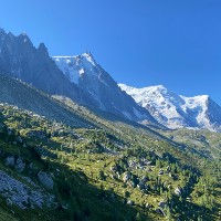
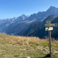
Some of the best views in Chamonix require that you climb 1000 meters or more in altitude so you can reach the plateaus above the valley. To make this easier, you can use the gondolas, cable cars, chair lifts and mountain trains that go up the mountains in and around Chamonix. This enables you to do some higher altitude trails that are still child and family friendly. Here is our list of the best lift and train assisted trails in and around Chamonix. We present two ways of findings these trails. Below we feature some pictures of lift assisted trails. If you see one you like, then click on it and it will show you where the picture was taken and which trails pass by that location.


Lift and Train assisted Trails in Chamonix
There are a large number of lifts and mountain trains operating in and around Chamonix. They definitely belong to some of the most spectacular ones in the world. Beyond their utility of enabling you to easily gain altitude, they are also just a fun ride sure to be enjoyed by you and your loved-ones. Most of these also end up on locations that have excellent infrastructure with easy access to refuges, snack bars and other points of interest. This is our list of the best lift and mountain train assisted trails in and around Chamonix.

Une route fantastique avec tant à offrir et une grande diversité de paysages et de vues. Ce sentier peut être parcouru avec des enfants tant qu'ils peuvent gérer la quantité importante de descente.
Length
Nearest Town
Starting Point
Route Type
10.99km / 6.82mi
Les Houches
La station du téléphérique de Bellevue
Avec téléphérique
Elevation +
651m / 2135ft
Elevation -
1278m / 4192ft
Technical
Hike Duration
Run Duration
3.5-6 Hours
2-3 Hours
Scenic Beauty
Length
Family Friendly, Snack Bar, Big Views, Glacier, Refuge, With Lift

Le moyen le plus facile d'atteindre le Lac Blanc est d'utiliser les remontées mécaniques de la Flégère et de l'Index, puis de traverser jusqu'au Lac Blanc avant de retourner à la Flégère. Une façon conviviale pour les familles de visiter le Lac Blanc.
Length
Nearest Town
Starting Point
Route Type
6.21km / 3.85mi
Argentiere
Station du télésiège de l'Index
Avec téléphérique
Elevation +
178m / 583ft
Elevation -
667m / 2188ft
Technical
Hike Duration
Run Duration
2-3 Hours
1-2 Hours
Scenic Beauty
Length
Big Views, Lake, Family Friendly, Refuge, Snack Bar, With Lift
Le Montenvers à Plan de l'Aiguille avec Lac Bleu est peut-être l'itinéraire le plus populaire de la vallée de Chamonix, vous emmenant de la station du Montenvers et de la Mer de Glace sur le Balcon Nord, en passant par le Lac Bleu jusqu'à la station de téléphérique du Plan de l'Aiguille.
Length
Nearest Town
Starting Point
Route Type
7.35km / 4.56mi
Chamonix
Gare du train du Montenvers
Avec téléphérique
Elevation +
471m / 1545ft
Elevation -
103m / 338ft
Technical
Hike Duration
Run Duration
2-3.5 Hours
1-1.5 Hours
Scenic Beauty
Length
Big Views, Refuge, Snack Bar, Family Friendly, Lake, Glacier, With Lift
Cette courte route commence au sommet du téléphérique de Bellevue et traverse le Mont Lachat jusqu'à ce que vous atteigniez son sommet. De belles vues sur toute la vallée de Chamonix et sur le Mont Blanc.
Length
Nearest Town
Starting Point
Route Type
3.88km / 2.41mi
Les Houches
La station du téléphérique de Bellevue
Avec téléphérique
Elevation +
311m / 1020ft
Elevation -
311m / 1020ft
Technical
Hike Duration
Run Duration
1.5-2.5 Hours
45-75 Mins
Scenic Beauty
Length
Snack Bar, Big Views, Family Friendly, Dogs, With Lift

Magnifique sentier familial à 2000 mètres d'altitude offrant une vue imprenable sur le Mont Blanc, avec un accès facile grâce aux télécabines de la Flégère et du Planpraz.
Length
Nearest Town
Starting Point
Route Type
5.64km / 3.50mi
Chamonix
Télécabine de la Flégère
Avec remontée mécanique
Elevation +
314m / 1030ft
Elevation -
191m / 626ft
Technical
Hike Duration
Run Duration
1.5-2 hours
45-75 Mins
Scenic Beauty
Length
Big Views, Family Friendly, Snack Bar, With Lift

Un sentier difficile mais magnifique qui vous emmène du Col des Montets jusqu'au Lac Blanc, puis vous traversez les Aiguilles Rouges et visitez les Lacs Noirs et le Lac Cornu.
Length
Nearest Town
Starting Point
Route Type
16.45km / 10.22mi
Le Tour
Col des Montets
Avec remontée mécanique
Elevation +
1552m / 5091ft
Elevation -
1011m / 3320ft
Technical
Hike Duration
Run Duration
7-12 Hours
4-6 Hours
Scenic Beauty
Length
Refuge, Snack Bar, Lake, Big Views, With Lift
The Best Trails in Chamonix in other categories
We have many other categories for our selection of the best hiking and trail running trails in Chamonix. Just like this list, all these categories feature hand-picked trails which we feel are the best for that specific category. Have a look at any of these to find your perfect trail.
Lastly, we also have a page that showcases all the trails in our database in text format. This enables you to quickly compare trails and order them by length, elevation gain, name and starting point.