Tramway du Mont Blanc
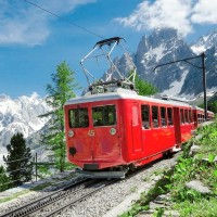
The Tramway du Mont Blanc is a high mountain cogwheel train that departs from Le Fayet (580m), below Saint-Gervais in the Montjoie Valley and travels all the way to the Nid d'Aigle (2372m) next to the Bionnassay Glacier. It is the highest train in France. There are 7 stops in total:
Le Fayet
Saint-Gervais
Montivon
Col de Voza
Bellevue
Mont Lachat
Nid d'Aigle
The Tramway du Mont BLanc meets the Bellevue cable car from the Les Houches side at the Bellevue station. Making it easier for people staying in the Chamonix Valley to meet the tramway there instead of having to travel to the Montjoie Valley first.
Tickets for the Tramway du Mont Blanc can be purchased online on the official website. After that you need to reserve your specific departure time online using the same official website. The trains have a capacity of 130 people and you will be guaranteed a spot but not a specific seat number. Babies younger than 6 months are not allowed to ride the train to the higher stations of Col de Voza, Bellevue, Lachat and Nid d'Aigle.
There is a rich history of plans to build a train to the top of Mont Blanc with multiple plans and routes being proposed in the period from 1835 to 1904. There is also fierce competition between plans that start the route from Chamonix and plans that start at Saint-Gervais. In 1904, the Saint-Gervais plan is approved and so starts the construction on the Tramway du Mont Blanc we know today. In 1909 the first segment from Le Fayet to the Col de Voza is inaugurated with 6 locomotives. In 1911 the line is extended to Mont Lachat. The first world war puts a halt to the progress which at that point had reached the Nid d'Aigle. In 1955 the company restructured and Pierre Noury becomes the 90% owner recapitlizing the company and enabling modernization. The names on the trains: Marie, Jeanne and Anne to this date point back to the names of the daughters of Pierre Noury. With fresh capital, in 1957 the switch from steam power to electricity is finally made dramatically increasing capacity and decreasing travel time, enabling the tramway to compete with the gondolas and cable cars that were rapidly gaining popularity.
NOTE: There are big renovation works happening this year (2023) and for this summer the Nid d'Aigle is closed to the general public and only open for people with a confirmed booking at the Refuges above the Nid d'Aigle on the way to the Mont Blanc Summit. The new Nid d'Aigle station is expected to open in 2026.
Type:
Mountain
Length:
12.4km
Children:
6+ Months Old
Elevation:
580m - 2372m
Website:
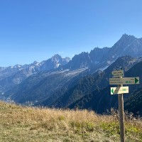
Nearby Trails & Points of Interest

Une route fantastique avec tant à offrir et une grande diversité de paysages et de vues. Ce sentier peut être parcouru avec des enfants tant qu'ils peuvent gérer la quantité importante de descente.
Length
Nearest Town
Starting Point
Route Type
10.99km / 6.82mi
Les Houches
La station du téléphérique de Bellevue
Avec téléphérique
Elevation Up
Elevation Up
651m / 2135ft
1278m / 4192ft
Difficulty
Hike Duration
Run Duration
Beauty
3.5-6 Hours
2-3 Hours
Tags
Family Friendly, Snack Bar, Big Views, Glacier, Refuge, With Lift
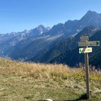
Cette courte route commence au sommet du téléphérique de Bellevue et traverse le Mont Lachat jusqu'à ce que vous atteigniez son sommet. De belles vues sur toute la vallée de Chamonix et sur le Mont Blanc.
Length
Nearest Town
Starting Point
Route Type
3.88km / 2.41mi
Les Houches
La station du téléphérique de Bellevue
Avec téléphérique
Elevation Up
Elevation Up
311m / 1020ft
311m / 1020ft
Difficulty
Hike Duration
Run Duration
Beauty
1.5-2.5 Hours
45-75 Mins
Tags
Snack Bar, Big Views, Family Friendly, Dogs, With Lift