top of page

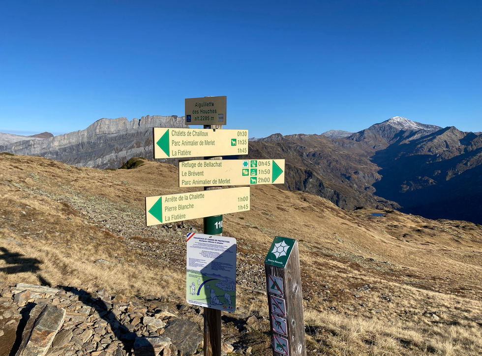
Aiguilette des Houches

Mountain Ridge

Contributors:

10

Our Rating

The Best

The Aiguillette des Houches is a crest summit located on the long crest trail that leads from Refuge de Belachat via the Aiguillette du Brevent and the Pointe de Lapaz all the way down to the Pierre Blanche. This is one of our favorite trails in Chamonix with arguably some of the best views imaginable of the Mont Blanc. The Aiguillette des Houches lies on a crossroads of a couple of trails. The before mentioned crest trail being one of them. There is also a major trail leading down towards Les Houches via de Chalets de Chailloux. There is also a northern trail heading towards the Lac de l'Aiguillette and the Col de Bellachat. This is definitely one of the more popular view points and one that should not be missed. The easiest access would be using the Brevent cable car. The shortest hike would start from Parc Merlet.

Nearest town to this point of interest

Nearest Town

Les Houches

Altitude of this point of interest

Altitude

2285m

Capacity for this point of interest
Accommodation Type
Phone number for this point of interest
Website for this point of interest

Capacity

Accommodation

Phone

Website

Mountain Ridge

Looking for more cols and summits?

Linked Trails & Points of Interest

These are the trails and points of interests linked to this Mountain Ridge

Merlet à Bellachat et Aiguillette des Houches

10

Our Rating

The Best

Trail:

View on Map

Vues spectaculaires sur celui-ci ! La marche sur la crête de Bellachat à l'Aiguillette des Houches est absolument spectaculaire. Merlet offre le moyen le plus facile d'accéder sans remontées mécaniques.

Trail Length

Length

10.94km

When is the best time to go on this trail

When to Go

Mid Jun - End Sep

How long does it take to hike this trail

Hiking Time

3.0 - 5.0 Hours

Elevation gain and loss for this trail

Elevation +

+1005m / -1005m

How old do kids have to be to go on this trail

Kids

9+ Years old

How long does it take to run this trail

Running Time

2.0 - 3.5 Hours

The technical difficulty level of this trail

Technical Difficulty

Moderate (3/5)

Are dogs allowed on this trail

Dogs

No Dogs

Nearest Town to this Trail

Nearest Town

Chamonix

Col de Bellachat

7

Our Rating

Good

Le col plat et large entre la Tête de Bellachat et l'Aiguillette de Brévent

Nearest town to this point of interest

Nearest Town

Chamonix

The altitude of this point of interest

Altitude

2130m

View on Map
Refuge de Bellachat

9

Our Rating

Exceptional

Refuge

Mountain refuge with a spectacular view of Mt Blanc and overlooking the Chamonix valley

Nearest town to this point of interest

Nearest Town

Chamonix

The altitude of this point of interest

Altitude

2152m

View on Map
Lac du Brevent

9

Our Rating

Exceptional

Le lac de montagne en haute altitude près du Brévent, situé au-dessus de Chamonix

Nearest town to this point of interest

Nearest Town

Chamonix

The altitude of this point of interest

Altitude

2130m

View on Map

Location & Map

Below you will the location of this point of interest on the map. You can click the button to show the nearby trails and points of interests that are listed above on the same map. Another option is to visit our complete interactive map that shows everything that is listed on our website.

Longitude:

6.80534

Latitude:

45.92129

Show nearby Trails & Points of Interest

Vous avez quelque chose à ajouter ?

Nous avons commencé au printemps 2023 et nous travaillons dur pour rendre ce site aussi complet et précis que possible. Nous avons besoin de votre aide ! Si vous avez quelque chose que vous aimeriez ajouter, n'hésitez pas à nous contacter.

Chamonix360 n'est pas une entreprise ni une organisation commerciale. Le site est géré par un groupe passionné de trail à Chamonix-Mont-Blanc

© 2023 Chamonix360  

bottom of page