top of page

Barberine

Ville

Contributors:

8

Our Rating

Very Good

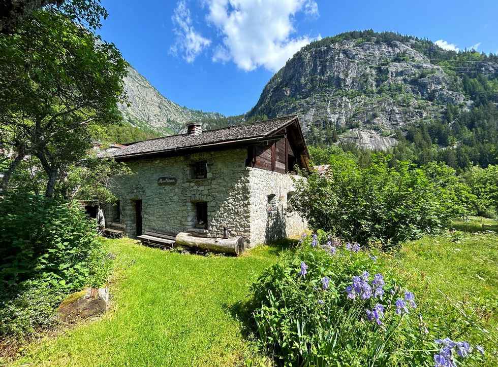
Barberine est un petit hameau situé à l'extrémité nord-est de la vallée de Vallorcine, juste à la frontière avec la Suisse. Le Torrent de Barberine est la petite rivière qui porte le même nom et prend sa source bien au-dessus de Barberine au barrage du Lac d'Émosson. Le Torrent de Barberine compte deux cascades que vous pouvez visiter : la Grande Cascade de Barberine, à environ 200 mètres au-dessus du hameau de Barberine, et la Petite Cascade de Barberine, également connue sous le nom de Cascade du Dard, qui se trouve à quelques centaines de mètres au nord du hameau.


Barberine ne compte que quelques bâtiments, mais l'un d'eux est très spécial : la Maison de Barberine. Cette structure est l'une des plus anciennes maisons de la vallée, datant de 1705. En 1987, une association avec 16 membres fondateurs a été créée dans le but d'acquérir la propriété et de la transformer en petit musée. Vous pouvez visiter ce musée pendant les mois de juillet et août. Il présente la vie ancienne de Vallorcine à travers les artefacts qui y sont exposés.


Le meilleur moyen d'accéder à Barberine est d'utiliser l'historique Chemin des Diligences depuis Vallorcine. C'est une belle promenade. Pendant votre séjour à Barberine, vous devriez traverser le torrent de Barberine et admirer la Petite Cascade de Barberine.

Nearest town to this point of interest

Nearest Town

Vallorcine

Altitude of this point of interest

Altitude

1163m

Capacity for this point of interest
Accommodation Type
Phone number for this point of interest
Website for this point of interest

Capacity

Accommodation

Phone

Website

Hameau

Looking for more refuges?

Refuges on our Interactive Map

Linked Trails & Points of Interest

These are the trails you can take that pass by this point of interest:

Vallorcine to Finhaut Loop

7

Our Rating

Good

Loop Trail:

View on Map

A long discovery loop trail between Vallorcine and Finhaut visiting 3 waterfalls, a spectacular view point and a number of other points of interest along the way

Trail Length

Length

20.13km

When is the best time to go on this trail

When to Go

End May - Mid Oct

How long does it take to hike this trail

Hiking Time

6.0 - 9.0 Hours

Elevation gain and loss for this trail

Elevation +

+1381m / -1381m

How old do kids have to be to go on this trail

Kids

15+ Years old

How long does it take to run this trail

Running Time

3.0 - 4.5 Hours

The technical difficulty level of this trail

Technical Difficulty

Moderate (3/5)

Are dogs allowed on this trail

Dogs

Dogs Allowed

Nearest Town to this Trail

Nearest Town

Chamonix

Vallorcine to Loriaz and Lac Emosson

9

Our Rating

Exceptional

Loop Trail:

View on Map

A beautiful loop in the Montagne de Loriaz and the Montagne de Barberine taking you from Vallorcine to the Refuge de Loriaz and then traversing to the big Lac d'Emosson lake.

Trail Length

Length

13.25km

When is the best time to go on this trail

When to Go

Start Jun - Start Oct

How long does it take to hike this trail

Hiking Time

4.0 - 6.0 Hours

Elevation gain and loss for this trail

Elevation +

+1022m / -1022m

How old do kids have to be to go on this trail

Kids

12+ Years old

How long does it take to run this trail

Running Time

2.5 - 4.0 Hours

The technical difficulty level of this trail

Technical Difficulty

Moderate (3/5)

Are dogs allowed on this trail

Dogs

Dogs Allowed

Nearest Town to this Trail

Nearest Town

Chamonix

Petite Cascade de Barberine

6

Our Rating

Above Average

Petite cascade près du hameau de Barberine

Nearest town to this point of interest

Nearest Town

Vallorcine

The altitude of this point of interest

Altitude

1165m

View on Map
Vallorcine

7

Our Rating

Good

Town

Quieter and more rural town at the nort-eastern end of the Chamonix Valley

Nearest town to this point of interest

Nearest Town

Vallorcine

The altitude of this point of interest

Altitude

1263m

View on Map
Lac Emosson

9

Our Rating

Exceptional

Lake

The largest mountain lake near Chamonix right across the border in Switzerland

Nearest town to this point of interest

Nearest Town

Vallorcine

The altitude of this point of interest

Altitude

1785m

View on Map
Grande Cascade de Barberine

7

Our Rating

Good

Cascade avec une belle plateforme d'observation au-dessus du hameau de Barberine

Nearest town to this point of interest

Nearest Town

Vallorcine

The altitude of this point of interest

Altitude

1324m

View on Map
Vallorcine

7

Our Rating

Good

Town

Quieter and more rural town at the nort-eastern end of the Chamonix Valley

Nearest town to this point of interest

Nearest Town

Vallorcine

The altitude of this point of interest

Altitude

1263m

View on Map

Location & Map

Below you will the location of this point of interest on the map. You can click the button to show the nearby trails and points of interests that are listed above on the same map. Another option is to visit our complete interactive map that shows everything that is listed on our website.

Longitude:

6.9415

Latitude:

46.0505

Show nearby Trails & Points of Interest

Vous avez quelque chose à ajouter ?

Nous avons commencé au printemps 2023 et nous travaillons dur pour rendre ce site aussi complet et précis que possible. Nous avons besoin de votre aide ! Si vous avez quelque chose que vous aimeriez ajouter, n'hésitez pas à nous contacter.

Chamonix360 n'est pas une entreprise ni une organisation commerciale. Le site est géré par un groupe passionné de trail à Chamonix-Mont-Blanc

© 2023 Chamonix360  

bottom of page