

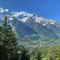
Chamonix-Mont-Blanc is the best town in the entire world and that is not just because our website is called Chamonix360! Chamonix owes its reputation to its proximity to Mont-Blanc, the highest mountain in Western-Europe. In 1924, Chamonix hosted the first winter olympics and its been a major winter sports destination ever since. It has also always had a pioneering role in alpinism and mountaineering.
The commune of Chamonix consists of 16 villages and hamlets and has a population of roughly 10,000 people. The permanent population of Chamonix dwarves in comparisson with the nearly 3 million tourists that visit it each year. The city center of Chamonix is well equipped with a busy and buzzing main shopping street and numerous hotels, hostels, restaurants and bars. All the big names in outdoor gear and equipment have their own in shop in Chamonix. To help tourists find their way there is a large and well staffed Tourism Office and Mountain Information Office. Overall, Chamonix is a fantastic basecamp for whatever outdoor adventure you could have in mind.
Chamonix sits right in the center of the Chamonix Valley and as such there are numerous trails that fan out in all directions. Being inside a steep valley means that the trails connecting to Chamonix will be either be located on the south facing slopes of the Aiguillles Rouge or on the north facing slopes of the Mont Blanc Massif. The Petite Balcon Sud and the Petite Balcon Nord are two low altitude trails that run across each side and link many of the towns and hamlets inside the Chamonix valley.
We will keep our coverage of Chamonix short. Afterall, this website is mostly interested what happens outside of the town of Chamonix. There are dozens of websites covering Chamonix hotels, restaurants, nightlife, etc. It is time for us to get back to what interests us most: the trails!


Linked Trails & Points of Interest
These are the trails and points of interests linked to this Town

4
Our Rating
Below Average
Point to Point Trail:
The Petit Balcon Sud (PBS) runs from Argentiere to Chamonix and further down the valley. This section of the PBS takes you from Argentiere to Chamonix
Length
8.83km
When to Go
Start Apr - Mid Nov
Hiking Time
2.0 - 3.0 Hours
Elevation +
+201m / -415m
Kids
7+ Years old
Running Time
1.0 - 1.5 Hours
Technical Difficulty
Very Easy (1/5)
Dogs
Dogs Allowed
Nearest Town
Chamonix

7
Our Rating
Good
Trail:
Ce sentier vous mène au Montenvers via la Buvette des Mottets, puis redescend via la Buvette Caillet. C'est une belle façon de monter au Montenvers si vous ne voulez pas utiliser le train.
Length
11.34km
When to Go
Start Jun - Mid Oct
Hiking Time
4.0 - 6.0 Hours
Elevation +
+855m / -855m
Kids
12+ Years old
Running Time
2.0 - 3.5 Hours
Technical Difficulty
Moderate (3/5)
Dogs
Dogs Allowed
Nearest Town
Chamonix

6
Our Rating
Above Average
Trail:
Un sentier court et adapté aux familles partant du parking du Grepon près de Chamonix Sud vous mène à la Cascade du Dard. Une belle cascade avec une buvette agréable juste à côté.
Length
3.38km
When to Go
Mid Apr - End Oct
Hiking Time
1.0 - 1.5 Hours
Elevation +
+284m / -284m
Kids
4+ Years old
Running Time
30 - 45 Mins
Technical Difficulty
Easy (2/5)
Dogs
Dogs Allowed
Nearest Town
Chamonix

8
Our Rating
Very Good
Trail:
Une grande mais magnifique ascension de Chamonix au sommet du Brévent via Bellachat et le Lac du Brévent. De grands panoramas et un terrain spectaculaire vous attendent.
Length
17.6km
When to Go
Start Jul - Mid Oct
Hiking Time
6.0 - 9.0 Hours
Elevation +
+1551m / -1551m
Kids
15+ Years old
Running Time
3.0 - 5.0 Hours
Technical Difficulty
Moderate (3/5)
Dogs
No Dogs
Nearest Town
Chamonix

6
Our Rating
Above Average
Trail:
La Floria est une buvette perché au-dessus du parcours de golf de Chamonix, offrant une belle vue sur la vallée ainsi que sur les aiguilles de Chamonix et la chaîne du Mont Blanc.
Length
5.5km
When to Go
Start Apr - End Oct
Hiking Time
75 - 100 Mins
Elevation +
+298m / -298m
Kids
7+ Years old
Running Time
40 - 60 Mins
Technical Difficulty
Easy (2/5)
Dogs
Dogs Allowed
Nearest Town
Chamonix
4
Our Rating
Below Average
Trail:
Ce sentier vous mène du centre de Chamonix au parc animalier Parc Merlet, situé au-dessus de Les Houches.
Length
5.98km
When to Go
Mid Apr - End Oct
Hiking Time
2.0 - 3.0 Hours
Elevation +
+645m / -163m
Kids
7+ Years old
Running Time
1.0 - 1.5 Hours
Technical Difficulty
Easy (2/5)
Dogs
Dogs Allowed
Nearest Town
Chamonix

7
Our Rating
Good
Trail:
Sentier facile et adapté aux familles, à basse altitude, qui vous emmène de Le Tour à Argentière, puis à Le Lavancher, pour finalement arriver à Chamonix en empruntant le Petit Balcon Nord (PBN).
Length
12.53km
When to Go
Mid Apr - End Oct
Hiking Time
2.5 - 4.0 Hours
Elevation +
+226m / -683m
Kids
7+ Years old
Running Time
1.5 - 2.5 Hours
Technical Difficulty
Very Easy (1/5)
Dogs
Dogs Allowed
Nearest Town
Chamonix


Location & Map
Below you will the location of this point of interest on the map. You can click the button to show the nearby trails and points of interests that are listed above on the same map. Another option is to visit our complete interactive map that shows everything that is listed on our website.
Longitude:
6.87184
Latitude:
45.92512