top of page

La-Haut Index-Flegere

Snack-bar

Contributors:

7

Our Rating

Good

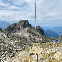
La-Haut Flégère est un snack-bar situé à côté du télésiège Index à une altitude impressionnante de 2400 mètres au-dessus de Chamonix. C'est un snack-bar à emporter qui ne propose pas de places assises intérieures ou couvertes. Ils disposent d'une superbe terrasse extérieure face au Massif du Mont Blanc avec une vue magnifique. Ils mettent un point d'honneur à n'utiliser que des produits locaux et proposent une variété de sandwiches, crêpes, glaces ainsi que des boissons alcoolisées et non alcoolisées. Ce qui est assez amusant, c'est qu'ils disposent d'un terrain de pétanque assez professionnel. Si vous n'êtes pas familier, la pétanque est un jeu populaire en France joué avec des boules métalliques ayant pour objectif général de rapprocher vos boules le plus possible du cochonnet. C'est donc un petit plus sympa à leur snack-bar.


Le moyen le plus facile d'accéder à La-Haut est de prendre le télésiège Index après avoir pris la télécabine de la Flégère depuis Les Praz. De La-Haut, vous pouvez emprunter le sentier en direction sud-ouest vers le Col de la Glière, le Col Cornu, les Lacs Noirs et le Lac Cornu. Nous avons une description détaillée de ce sentier. Si vous partez en direction nord-est, vous pouvez traverser jusqu'au Lac Blanc et au Refuge Lac Blanc. Nous avons également une description détaillée de ce sentier.

Nearest town to this point of interest

Nearest Town

Chamonix

Altitude of this point of interest

Altitude

2400m

Capacity for this point of interest
Accommodation Type
Phone number for this point of interest
Website for this point of interest

Capacity

Accommodation

Phone

Website

Snack-bar

Looking for more refuges?

Refuges on our Interactive Map

Linked Trails & Points of Interest

These are the trails you can take that pass by this point of interest:

Col des Montets à Plan Praz via les Lacs

9

Our Rating

Exceptional

Trail:

View on Map

Un sentier difficile mais magnifique qui vous emmène du Col des Montets jusqu'au Lac Blanc, puis vous traversez les Aiguilles Rouges et visitez les Lacs Noirs et le Lac Cornu.

Trail Length

Length

16.45km

When is the best time to go on this trail

When to Go

End Jun - End Sep

How long does it take to hike this trail

Hiking Time

7.0 - 12.0 Hours

Elevation gain and loss for this trail

Elevation +

+1552m / -1011m

How old do kids have to be to go on this trail

Kids

15+ Years old

How long does it take to run this trail

Running Time

4.0 - 6.0 Hours

The technical difficulty level of this trail

Technical Difficulty

Very Difficult (5/5)

Are dogs allowed on this trail

Dogs

No Dogs

Nearest Town to this Trail

Nearest Town

Chamonix

Index jusqu'au Lac Blanc avec Télésièges

8

Our Rating

Very Good

Trail:

View on Map

Le moyen le plus facile d'atteindre le Lac Blanc est d'utiliser les remontées mécaniques de la Flégère et de l'Index, puis de traverser jusqu'au Lac Blanc avant de retourner à la Flégère. Une façon conviviale pour les familles de visiter le Lac Blanc.

Trail Length

Length

6.21km

When is the best time to go on this trail

When to Go

Mid Jun - Mid Sep

How long does it take to hike this trail

Hiking Time

2.0 - 3.0 Hours

Elevation gain and loss for this trail

Elevation +

+178m / -667m

How old do kids have to be to go on this trail

Kids

7+ Years old

How long does it take to run this trail

Running Time

1.0 - 2.0 Hours

The technical difficulty level of this trail

Technical Difficulty

Easy (2/5)

Are dogs allowed on this trail

Dogs

No Dogs

Nearest Town to this Trail

Nearest Town

Chamonix

Lac Blanc

9

Our Rating

Exceptional

Lake

One of the most popular lakes in the Chamonix Valley with great reflections of the Mont Blanc

Nearest town to this point of interest

Nearest Town

Argentiere

The altitude of this point of interest

Altitude

2352m

View on Map
Col de la Gliere

7

Our Rating

Good

Mountain Pass

Mountain pass above the Grand Balcon Sud near the Lacs Noirs and Lac Cornu

Nearest town to this point of interest

Nearest Town

Chamonix

The altitude of this point of interest

Altitude

2461m

View on Map
Col Cornu

7

Our Rating

Good

Mountain Pass

Mountain pass near Lac Cornu high above the Grand Balcon Sud

Nearest town to this point of interest

Nearest Town

Chamonix

The altitude of this point of interest

Altitude

2406m

View on Map
Refuge Lac Blanc

8

Our Rating

Very Good

Refuge

Popular Refuge at the shores of the famous Lac Blanc

Nearest town to this point of interest

Nearest Town

Argentiere

The altitude of this point of interest

Altitude

2353m

View on Map
Lacs Noirs

6

Our Rating

Above Average

Lake

Two small lakes near de Col de la Gliere, reachable using the Index life at Flegere

Nearest town to this point of interest

Nearest Town

Chamonix

The altitude of this point of interest

Altitude

2550m

View on Map
Lac Cornu

7

Our Rating

Good

Lake

Pictoresque lake located north from the Col du Cornu

Nearest town to this point of interest

Nearest Town

Chamonix

The altitude of this point of interest

Altitude

2276m

View on Map

Location & Map

Below you will the location of this point of interest on the map. You can click the button to show the nearby trails and points of interests that are listed above on the same map. Another option is to visit our complete interactive map that shows everything that is listed on our website.

Longitude:

6.8748

Latitude:

45.9689

Show nearby Trails & Points of Interest

Vous avez quelque chose à ajouter ?

Nous avons commencé au printemps 2023 et nous travaillons dur pour rendre ce site aussi complet et précis que possible. Nous avons besoin de votre aide ! Si vous avez quelque chose que vous aimeriez ajouter, n'hésitez pas à nous contacter.

Chamonix360 n'est pas une entreprise ni une organisation commerciale. Le site est géré par un groupe passionné de trail à Chamonix-Mont-Blanc

© 2023 Chamonix360  

bottom of page