top of page

Refuge de Loriaz

Refuge

Contributors:

8

Our Rating

Very Good

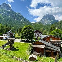
The Refuge de Loriaz is a beautifully situated refuge in the Montagne de Loriaz above Vallorcine with great views over the Aiguille Verte and the Mont Blanc Massif. It is surrounded by beautiful pastures and has some excellent trails that can be made as part of a visit to this this refuge. We got a very nice trail that starts in Vallorcine, climbs up to the refuge and then traverses to Lac Emosson. Another great route is climbing the summit of Mont Buet via the Refuge de Loriaz and the Cheval Blanc. 


The refuge has a capacity of 30 divided over 3 dormitories. The refuge will provide pillows and blanket but you will need to bring your own liner or rent one from the refuge. Dogs are not allowed inside the buildings. The refuge's website says that the refuge is open all year but suggests you check before going there to make sure. Bookings need to be made ahead of time. They also offer snacks and simple meals for visitors.

Nearest town to this point of interest

Nearest Town

Vallorcine

Altitude of this point of interest

Altitude

2020m

Capacity for this point of interest
Accommodation Type
Phone number for this point of interest
Website for this point of interest

Capacity

Accommodation

Phone

Website

40

Dormitories

+33 (0)6 52 53 69 73

Looking for more refuges?

Linked Trails & Points of Interest

These are the trails and points of interests linked to this refuge

Loriaz jusqu'au Mont Buet en passant par le Cheval Blanc.

10

Our Rating

The Best

Trail:

View on Map

Un itinéraire difficile qui vous emmène au sommet du Mont Buet à 3096m en passant par le Refuge de Loriaz, le Col de la Terrasse et le Cheval Blanc.

Trail Length

Length

23.31km

When is the best time to go on this trail

When to Go

Mid Jul - End Sep

How long does it take to hike this trail

Hiking Time

8.0 - 13.7 Hours

Elevation gain and loss for this trail

Elevation +

+2048m / -2048m

How old do kids have to be to go on this trail

Kids

15+ Years old

How long does it take to run this trail

Running Time

5.0 - 8.0 Hours

The technical difficulty level of this trail

Technical Difficulty

Very Difficult (5/5)

Are dogs allowed on this trail

Dogs

No Dogs

Nearest Town to this Trail

Nearest Town

Chamonix

Vallorcine to Loriaz and Lac Emosson

9

Our Rating

Exceptional

Loop Trail:

View on Map

A beautiful loop in the Montagne de Loriaz and the Montagne de Barberine taking you from Vallorcine to the Refuge de Loriaz and then traversing to the big Lac d'Emosson lake.

Trail Length

Length

13.25km

When is the best time to go on this trail

When to Go

Start Jun - Start Oct

How long does it take to hike this trail

Hiking Time

4.0 - 6.0 Hours

Elevation gain and loss for this trail

Elevation +

+1022m / -1022m

How old do kids have to be to go on this trail

Kids

12+ Years old

How long does it take to run this trail

Running Time

2.5 - 4.0 Hours

The technical difficulty level of this trail

Technical Difficulty

Moderate (3/5)

Are dogs allowed on this trail

Dogs

Dogs Allowed

Nearest Town to this Trail

Nearest Town

Chamonix

Col de la Terrasse

7

Our Rating

Good

Le col de montagne rocheux près du Lac Vert entre Loriaz et le Cheval Blanc

Nearest town to this point of interest

Nearest Town

Vallorcine

The altitude of this point of interest

Altitude

2645m

View on Map
Le Buet

7

Our Rating

Good

Petit hameau situé à l'extrémité de la vallée de Bérard près de Vallorcine

Nearest town to this point of interest

Nearest Town

Vallorcine

The altitude of this point of interest

Altitude

1344m

View on Map
Vallorcine

7

Our Rating

Good

Town

Quieter and more rural town at the nort-eastern end of the Chamonix Valley

Nearest town to this point of interest

Nearest Town

Vallorcine

The altitude of this point of interest

Altitude

1263m

View on Map
Lac Emosson

9

Our Rating

Exceptional

Lake

The largest mountain lake near Chamonix right across the border in Switzerland

Nearest town to this point of interest

Nearest Town

Vallorcine

The altitude of this point of interest

Altitude

1785m

View on Map

Location & Map

Below you will the location of this point of interest on the map. You can click the button to show the nearby trails and points of interests that are listed above on the same map. Another option is to visit our complete interactive map that shows everything that is listed on our website.

Longitude:

6.913238047802821

Latitude:

46.038989107690945

Show nearby Trails & Points of Interest

Vous avez quelque chose à ajouter ?

Nous avons commencé au printemps 2023 et nous travaillons dur pour rendre ce site aussi complet et précis que possible. Nous avons besoin de votre aide ! Si vous avez quelque chose que vous aimeriez ajouter, n'hésitez pas à nous contacter.

Chamonix360 n'est pas une entreprise ni une organisation commerciale. Le site est géré par un groupe passionné de trail à Chamonix-Mont-Blanc

© 2023 Chamonix360  

bottom of page