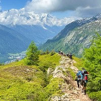
Autannes Chair Lift
The Autannes Chair Lift is a 4-seater chair lift that runs from the Charamillon mid-station (1859m) on the Balme Mountain to the Autannes end station (2199m) near the Col de Balme and the Swiss Border. The mid station is reached using the Charmillon gondola which starts at the hamlet of Le Tour at the north-eastern end of the Chamonix Valley. The Autannes lift enables easier acccess to the Refuge Albert 1er, next to the Glacier du Tour. There are also trails leading over the Col de Balme to Switzerland and westward to Vallorcine.
The ground station in Le Tour has a ticket office where you can buy tickets directly on the same day. This building is brand new having only been launched in 2022. For exact operating dates, ticket prices and to buy your tickets online, visit the official website.
Development of the Balme Mountain had a fairly late start compared to the other mountains around the Chamonix Valley. The first lift was built in 1937 with the Autannes 2nd stage lift being built in 1958. The current 4-seater lift dates back to 1994. For a lot more historical and technical information about this lift, you can visit the French Remontee-Mechanique website.

Nearby Trails & Points of Interest

Cet itinéraire vous emmène du village du Tour au refuge de haute altitude Albert 1er, juste à côté du Glacier du Tour.
Length
Nearest Town
Starting Point
Route Type
9.31km / 5.78mi
Le Tour
Le Tour
Aller-retour
Elevation Up
Elevation Up
862m / 2828ft
862m / 2828ft
Difficulty
Hike Duration
Run Duration
Beauty
3-5 Hours
1.5-2.5 Hours
Tags
Refuge, Glacier, Big Views, With Lift

Une fantastique petite boucle qui utilise les remontées mécaniques depuis Le Tour pour explorer les points de vue autour de la Tête de Balme, en visitant la Croix de Fer et les Chalets de Catogne.
Length
Nearest Town
Starting Point
Route Type
7.4km / 4.59mi
Le Tour
Le télésiège des Autannes
Boucle
Elevation Up
Elevation Up
391m / 1282ft
391m / 1282ft
Difficulty
Hike Duration
Run Duration
Beauty
2-3 Hours
1-1.5 Hours
Tags
Refuge, Big Views, With Lift