

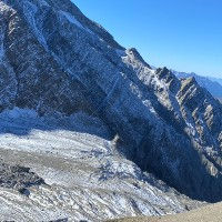
Beautiful refuge and restaurant in a fantastic location in the center of the Miage valley at the the foot of the Glacier de Miage. There are wide open pastures around the chalets with a number of small rivers running down from the high peaks around it. It is really very nice natural setting with good views all around.
The refuge has a capacity of 48 in its dormitory but also provides 2 private rooms and even 3 mini chalets. It serves excellent food and is open quite early in the season typically from May to the end of September. Check their website for the most information on the dates that they will be open for business and to make bookings.
Our favorite way of reaching the Chalets the Miage is by starting at Les Houches and taking the Bellevue lift and then taking the beautiful trail over the Col de Tricot down to the refuge. This is a good alternative to the usual Tour du Mont Blanc route and it our preferred alternative for Stage 1 of that multi-day tour.
We also have a trail that starts at the Chalet de Miage and takes you up to Col de Tricot and then takes the "Smugglers Path" to the Refuge Plan de Glacier. You could also reach the Chalet de Miage from Les Contamines by taking the trail passing by the Chalets du Truc.


Linked Trails & Points of Interest
These are the trails and points of interests linked to this refuge

9
Our Rating
Exceptional
Trail:
Une route fantastique avec tant à offrir et une grande diversité de paysages et de vues. Ce sentier peut être parcouru avec des enfants tant qu'ils peuvent gérer la quantité importante de descente.
Length
10.99km
When to Go
Mid Jun - Mid Sep
Hiking Time
2.5 - 4.0 Hours
Elevation +
+651m / -1278m
Kids
7+ Years old
Running Time
2.0 - 3.0 Hours
Technical Difficulty
Moderate (3/5)
Dogs
Dogs Allowed
Nearest Town
Chamonix

6
Our Rating
Above Average
Trail:
Une belle mais assez difficile boucle de sentier vous emmène du Refuge de Miage jusqu'au Col de Tricot, puis au Refuge de Plan de Glacier via le "Chemin des Contrebandiers".
Length
10.17km
When to Go
Mid Jun - End Sep
Hiking Time
4.0 - 6.0 Hours
Elevation +
+1181m / -1181m
Kids
15+ Years old
Running Time
2.5 - 3.5 Hours
Technical Difficulty
Very Difficult (5/5)
Dogs
No Dogs
Nearest Town
Chamonix


Location & Map
Below you will the location of this point of interest on the map. You can click the button to show the nearby trails and points of interests that are listed above on the same map. Another option is to visit our complete interactive map that shows everything that is listed on our website.
Longitude:
6.760161836997067
Latitude:
45.83920352568481