top of page

Col de Tricot

Mountain Pass

Contributors:

9

Our Rating

Exceptional

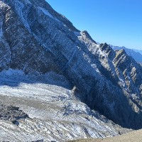
The Col de Tricot is located in between Mont Vorassay and the Aiguille de Bionnassay. The main trail that passes by the col runs from the Glacier de Bionnassay valley to the valley that is formed by the Glacier de Miage. The Chalets de Miage, which have a very nice restaurant and refuge, lies below the col and is reachable by a fairly steep and rocky path. 


There is a side trail from the Col de Tricot which brings you to the Plan de Glacier refuge via the so-called "Smugglers Path".  The Col de Tricot is popular as an alternative route for the Tour du Mont Blanc with people staying either at the Chalets de Miage or Chalets du Truc. It is definitely not as busy as the hotspots inside the Chamonix Valley.

Nearest town to this point of interest

Nearest Town

Les Houches

Altitude of this point of interest

Altitude

2120m

Capacity for this point of interest
Accommodation Type
Phone number for this point of interest
Website for this point of interest

Capacity

Accommodation

Phone

Website

Mountain Pass

Looking for more cols and summits?

Linked Trails & Points of Interest

These are the trails and points of interests linked to this Mountain Pass

De Bellevue aux Contamines via Tricot

9

Our Rating

Exceptional

Trail:

View on Map

Une route fantastique avec tant à offrir et une grande diversité de paysages et de vues. Ce sentier peut être parcouru avec des enfants tant qu'ils peuvent gérer la quantité importante de descente.

Trail Length

Length

10.99km

When is the best time to go on this trail

When to Go

Mid Jun - Mid Sep

How long does it take to hike this trail

Hiking Time

2.5 - 4.0 Hours

Elevation gain and loss for this trail

Elevation +

+651m / -1278m

How old do kids have to be to go on this trail

Kids

7+ Years old

How long does it take to run this trail

Running Time

2.0 - 3.0 Hours

The technical difficulty level of this trail

Technical Difficulty

Moderate (3/5)

Are dogs allowed on this trail

Dogs

Dogs Allowed

Nearest Town to this Trail

Nearest Town

Chamonix

Miage à Tricot et Plan de Glacier

6

Our Rating

Above Average

Trail:

View on Map

Une belle mais assez difficile boucle de sentier vous emmène du Refuge de Miage jusqu'au Col de Tricot, puis au Refuge de Plan de Glacier via le "Chemin des Contrebandiers".

Trail Length

Length

10.17km

When is the best time to go on this trail

When to Go

Mid Jun - End Sep

How long does it take to hike this trail

Hiking Time

4.0 - 6.0 Hours

Elevation gain and loss for this trail

Elevation +

+1181m / -1181m

How old do kids have to be to go on this trail

Kids

15+ Years old

How long does it take to run this trail

Running Time

2.5 - 3.5 Hours

The technical difficulty level of this trail

Technical Difficulty

Very Difficult (5/5)

Are dogs allowed on this trail

Dogs

No Dogs

Nearest Town to this Trail

Nearest Town

Chamonix

Chalets de Miage

9

Our Rating

Exceptional

Refuge

Large Refuge with dormitories, private rooms and small chalets in the Miage valley

Nearest town to this point of interest

Nearest Town

Les Contamines

The altitude of this point of interest

Altitude

1560m

View on Map
Glacier de Miage

7

Our Rating

Good

Glacier

This glacier forms the Miage valley below the Dome du Miage west from Mont Blanc

Nearest town to this point of interest

Nearest Town

Les Contamines

The altitude of this point of interest

Altitude

2700m

View on Map
Refuge de Plan de Glacier

7

Our Rating

Good

Refuge

Spectacularly located little refuge perched against a rock side near the Glacier de Miage

Nearest town to this point of interest

Nearest Town

Les Contamines

The altitude of this point of interest

Altitude

2680m

View on Map
Glacier de Bionnassay

8

Our Rating

Very Good

Glacier

Large glacier on the south-western side of the Mont Blanc Massif

Nearest town to this point of interest

Nearest Town

Les Houches

The altitude of this point of interest

Altitude

2500m

View on Map

Location & Map

Below you will the location of this point of interest on the map. You can click the button to show the nearby trails and points of interests that are listed above on the same map. Another option is to visit our complete interactive map that shows everything that is listed on our website.

Longitude:

6.77

Latitude:

45.85041

Show nearby Trails & Points of Interest

Vous avez quelque chose à ajouter ?

Nous avons commencé au printemps 2023 et nous travaillons dur pour rendre ce site aussi complet et précis que possible. Nous avons besoin de votre aide ! Si vous avez quelque chose que vous aimeriez ajouter, n'hésitez pas à nous contacter.

Chamonix360 n'est pas une entreprise ni une organisation commerciale. Le site est géré par un groupe passionné de trail à Chamonix-Mont-Blanc

© 2023 Chamonix360  

bottom of page