

Tre-le-Champ is a beautiful hamlet at the north-western end of the Chamonix Valley. It has a unique location sitting on a hillside with the valley towards Le Tour and the road towards Vallorcine on the other side. The hamlet is split into two parts: Tre-le-Champ-le-Haut and Tre-le-Champ-le-Bas, basically meaning the upper and lower parts of the hamlet.
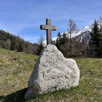
Tre-le-Champ is a very rural hamlet consisting mostly of farm houses and chalets spread out over grassy pastures. It has one refuge and restaurant called the Auberge la Boerne located right at the heart of the hamlet near the wooden cross of Tre-le-Champ. On the trail from Les Frasserands you will come across a number of wooden totems on a hillside with a nice view over the valley. We would love to know who made them and why and if someone knows then please contact us. There is a smaller cross a little further down the trail from the Auberge la Boerne but this may be located on private property. We got a very nice discovery trail running from Argentiere to Le Planet, Montroc and Tre-le-Champ that we can highly recommend.
There is a parking area along the main road going up to Vallorcine very near to Tre-le-Champ-le-Haut. That is the best place to park if you wish to visit the hamlet. The train station of Montroc-le-Planet can be used if you want to reach it by train. There is also a bus stop in Montroc that you can use.


Linked Trails & Points of Interest
These are the trails and points of interests linked to this Hamlet

7
Our Rating
Good
Trail:
Il s'agit d'une boucle de découverte très agréable et adaptée aux familles, explorant les villages d'Argentière, Le Planet, Montroc et Tré-le-Champ, ainsi que les nombreux points d'intérêt tout au long du parcours.
Length
7.57km
When to Go
Mid May - End Oct
Hiking Time
2.0 - 3.0 Hours
Elevation +
+325m / -325m
Kids
7+ Years old
Running Time
1.0 - 1.5 Hours
Technical Difficulty
Very Easy (1/5)
Dogs
Dogs Allowed
Nearest Town
Chamonix

8
Our Rating
Very Good
Trail:
Une boucle fantastique et adaptée aux familles entre les hameaux du Tour et de Montroc, offrant une belle variété de forêts, de vues et de charmants hameaux.
Length
4.56km
When to Go
End Apr - End Oct
Hiking Time
1.5 - 2.0 Hours
Elevation +
+226m / -226m
Kids
4+ Years old
Running Time
45 - 75 Mins
Technical Difficulty
Easy (2/5)
Dogs
Dogs Allowed
Nearest Town
Chamonix


Location & Map
Below you will the location of this point of interest on the map. You can click the button to show the nearby trails and points of interests that are listed above on the same map. Another option is to visit our complete interactive map that shows everything that is listed on our website.
Longitude:
6.9285
Latitude:
45.9959