top of page

Grotte a Farinet

Grotte

Contributors:

8

Our Rating

Very Good

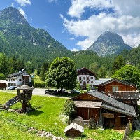
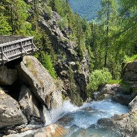
La Grotte à Farinet est une petite grotte située derrière la Buvette de Bérard, à la Cascade de Bérard. La grotte est accessible via un nouveau sentier créé au début de 2023. Le sentier passe derrière le snack-bar sur le côté gauche. Vous verrez un panneau indiquant son emplacement. À partir de là, quelques escaliers métalliques et ponts permettent d'atteindre l'entrée de la grotte. La grotte elle-même est constituée d'un seul espace ouvert avec deux puits de lumière et un éclairage artificiel activé par détecteur de mouvement. À l'intérieur de la grotte, il y a quelques panneaux d'information. La grotte n'est pas très grande, mais avec la cascade spectaculaire et la buvette, c'est définitivement un endroit fantastique à visiter.


Nous avons un court circuit qui commence au parking du Le Buet et qui visite la cascade, la buvette et la grotte, puis emprunte un joli sentier panoramique pour revenir au point de départ. C'est fortement recommandé pour les familles avec enfants ou les personnes recherchant un court sentier avec de superbes paysages. Nous avons également deux sentiers plus longs. L'un est l'ascension du Mont Buet et l'autre est le long sentier traversant tout le Valon Bérard jusqu'à Servoz.

Nearest town to this point of interest

Nearest Town

Vallorcine

Altitude of this point of interest

Altitude

1454m

Capacity for this point of interest
Accommodation Type
Phone number for this point of interest
Website for this point of interest

Capacity

Accommodation

Phone

Website

Grotte de roche

Looking for more refuges?

Refuges on our Interactive Map

Linked Trails & Points of Interest

These are the trails you can take that pass by this point of interest:

La Petite Boucle de la Cascade de Berrard

9

Our Rating

Exceptional

Trail:

View on Map

Une petite mais magnifique boucle près de Le Buet mettant en vedette la cascade de Bérard et une buvette, la grotte Farinet et des sentiers bordés de sculptures en bois.

Trail Length

Length

3.33km

When is the best time to go on this trail

When to Go

End Apr - Mid Oct

How long does it take to hike this trail

Hiking Time

50 - 80 Mins

Elevation gain and loss for this trail

Elevation +

+116m / -116m

How old do kids have to be to go on this trail

Kids

4+ Years old

How long does it take to run this trail

Running Time

25 - 40 Mins

The technical difficulty level of this trail

Technical Difficulty

Easy (2/5)

Are dogs allowed on this trail

Dogs

Dogs Allowed

Nearest Town to this Trail

Nearest Town

Chamonix

Le Buet à Servoz via Pormenaz

9

Our Rating

Exceptional

Trail:

View on Map

Un itinéraire incroyable qui vous plonge au cœur de la réserve naturelle de Passy et du Vallon de Bérard. Il n'y a pas de villes ni de routes pavées dans ces vallées, c'est donc une expérience purement naturelle.

Trail Length

Length

25.66km

When is the best time to go on this trail

When to Go

End Jun - Start Oct

How long does it take to hike this trail

Hiking Time

7.0 - 11.0 Hours

Elevation gain and loss for this trail

Elevation +

+1489m / -2067m

How old do kids have to be to go on this trail

Kids

15+ Years old

How long does it take to run this trail

Running Time

4.0 - 6.0 Hours

The technical difficulty level of this trail

Technical Difficulty

Moderate (3/5)

Are dogs allowed on this trail

Dogs

No Dogs

Nearest Town to this Trail

Nearest Town

Chamonix

Le Mont Buet via Tre les Eaux Loop

10

Our Rating

The Best

Trail:

View on Map

Un itinéraire long et exigeant vous menant à travers la magnifique vallée de Tré-les-Eaux jusqu'au Cheval Blanc et au sommet du Mont Buet, avant de revenir en boucle via le Refuge Bérard.

Trail Length

Length

22.3km

When is the best time to go on this trail

When to Go

Mid Jul - End Sep

How long does it take to hike this trail

Hiking Time

8.0 - 13.0 Hours

Elevation gain and loss for this trail

Elevation +

+2103m / -2103m

How old do kids have to be to go on this trail

Kids

15+ Years old

How long does it take to run this trail

Running Time

5.0 - 8.0 Hours

The technical difficulty level of this trail

Technical Difficulty

Very Difficult (5/5)

Are dogs allowed on this trail

Dogs

No Dogs

Nearest Town to this Trail

Nearest Town

Chamonix

Loriaz jusqu'au Mont Buet en passant par le Cheval Blanc.

10

Our Rating

The Best

Trail:

View on Map

Un itinéraire difficile qui vous emmène au sommet du Mont Buet à 3096m en passant par le Refuge de Loriaz, le Col de la Terrasse et le Cheval Blanc.

Trail Length

Length

23.31km

When is the best time to go on this trail

When to Go

Mid Jul - End Sep

How long does it take to hike this trail

Hiking Time

8.0 - 13.7 Hours

Elevation gain and loss for this trail

Elevation +

+2048m / -2048m

How old do kids have to be to go on this trail

Kids

15+ Years old

How long does it take to run this trail

Running Time

5.0 - 8.0 Hours

The technical difficulty level of this trail

Technical Difficulty

Very Difficult (5/5)

Are dogs allowed on this trail

Dogs

No Dogs

Nearest Town to this Trail

Nearest Town

Chamonix

Buvette de Berard

9

Our Rating

Exceptional

Snack Bar

Great snack bar perched above the Cascade de Berard waterfall

Nearest town to this point of interest

Nearest Town

Vallorcine

The altitude of this point of interest

Altitude

1429m

View on Map
Cross at La Poya

7

Our Rating

Good

Cross

Big Wooden across at the hamlet of La Poya near Vallorcine

Nearest town to this point of interest

Nearest Town

Vallorcine

The altitude of this point of interest

Altitude

1383m

View on Map
Le Buet

7

Our Rating

Good

Petit hameau situé à l'extrémité de la vallée de Bérard près de Vallorcine

Nearest town to this point of interest

Nearest Town

Vallorcine

The altitude of this point of interest

Altitude

1344m

View on Map
Cascade du Berard

9

Our Rating

Exceptional

Waterfall

Beautiful waterfall with little snack bar at the start of the Berard Valley.

Nearest town to this point of interest

Nearest Town

Vallorcine

The altitude of this point of interest

Altitude

1429m

View on Map
Refuge de la Pierre a Berard

8

Our Rating

Very Good

Refuge

Refuge located at the end of the valley in the Vallon de Berard nature reserve

Nearest town to this point of interest

Nearest Town

Vallorcine

The altitude of this point of interest

Altitude

1925m

View on Map

Location & Map

Below you will the location of this point of interest on the map. You can click the button to show the nearby trails and points of interests that are listed above on the same map. Another option is to visit our complete interactive map that shows everything that is listed on our website.

Longitude:

6.9118

Latitude:

46.0205

Show nearby Trails & Points of Interest

Vous avez quelque chose à ajouter ?

Nous avons commencé au printemps 2023 et nous travaillons dur pour rendre ce site aussi complet et précis que possible. Nous avons besoin de votre aide ! Si vous avez quelque chose que vous aimeriez ajouter, n'hésitez pas à nous contacter.

Chamonix360 n'est pas une entreprise ni une organisation commerciale. Le site est géré par un groupe passionné de trail à Chamonix-Mont-Blanc

© 2023 Chamonix360  

bottom of page