

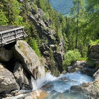
The Buvette de la Cascade de Berard is a fantastic little Buvette, or Snack Bar perched above the very spectacular Cascade de Berard. It has a nice wooden deck sticking out above the water fall and a nice bridge crossing the river before the water fall. They serve snack and drinks and are open in summer and apparently also at times in winter although I have not witnessed this myself yet.
The snack bar is a fantasic spot to bring your children on the short route coming up from Le Buet parking or train station. It can also serve as a great spot for a celebration beer after doing some of the longer routes coming in the direction of Servoz or the Le Buet summit.


Linked Trails & Points of Interest
These are the trails and points of interests linked to this Snack Bar

9
Our Rating
Exceptional
Trail:
Une petite mais magnifique boucle près de Le Buet mettant en vedette la cascade de Bérard et une buvette, la grotte Farinet et des sentiers bordés de sculptures en bois.
Length
3.33km
When to Go
End Apr - Mid Oct
Hiking Time
50 - 80 Mins
Elevation +
+116m / -116m
Kids
4+ Years old
Running Time
25 - 40 Mins
Technical Difficulty
Easy (2/5)
Dogs
Dogs Allowed
Nearest Town
Chamonix

9
Our Rating
Exceptional
Trail:
Un itinéraire incroyable qui vous plonge au cœur de la réserve naturelle de Passy et du Vallon de Bérard. Il n'y a pas de villes ni de routes pavées dans ces vallées, c'est donc une expérience purement naturelle.
Length
25.66km
When to Go
End Jun - Start Oct
Hiking Time
7.0 - 11.0 Hours
Elevation +
+1489m / -2067m
Kids
15+ Years old
Running Time
4.0 - 6.0 Hours
Technical Difficulty
Moderate (3/5)
Dogs
No Dogs
Nearest Town
Chamonix

10
Our Rating
The Best
Trail:
Un itinéraire difficile qui vous emmène au sommet du Mont Buet à 3096m en passant par le Refuge de Loriaz, le Col de la Terrasse et le Cheval Blanc.
Length
23.31km
When to Go
Mid Jul - End Sep
Hiking Time
8.0 - 13.7 Hours
Elevation +
+2048m / -2048m
Kids
15+ Years old
Running Time
5.0 - 8.0 Hours
Technical Difficulty
Very Difficult (5/5)
Dogs
No Dogs
Nearest Town
Chamonix


Location & Map
Below you will the location of this point of interest on the map. You can click the button to show the nearby trails and points of interests that are listed above on the same map. Another option is to visit our complete interactive map that shows everything that is listed on our website.
Longitude:
6.911560368517088
Latitude:
46.020004845223326