

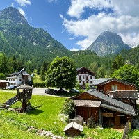
The Cascade du Berard is a stunning waterfall situated at the start of the Berard valley, near the village of Vallorcine. This is arguably the nicest waterfall in the direct vicinity of the Chamonix Valley. There is metal walkway mounted on the steep rocks on the side of the waterfall enabling you to get really up close to the massive water flow and it also provides great views into the valley below. There is a via ferrata trail that crosses the ravine in front of the waterfall multiple times. It looks pretty spectacular but not for the faint of heart.
The waterfall is easily accessible by a relatively easy hike from the nearby village of Le Buet which can be reached from Chamonix by train or by car. There is a super nice snack bar at the top of the waterfall serving snacks and drinks.


Linked Trails & Points of Interest
These are the trails and points of interests linked to this waterfall.

9
Our Rating
Exceptional
Trail:
Une petite mais magnifique boucle près de Le Buet mettant en vedette la cascade de Bérard et une buvette, la grotte Farinet et des sentiers bordés de sculptures en bois.
Length
3.33km
When to Go
End Apr - Mid Oct
Hiking Time
50 - 80 Mins
Elevation +
+116m / -116m
Kids
4+ Years old
Running Time
25 - 40 Mins
Technical Difficulty
Easy (2/5)
Dogs
Dogs Allowed
Nearest Town
Chamonix

9
Our Rating
Exceptional
Trail:
Un itinéraire incroyable qui vous plonge au cœur de la réserve naturelle de Passy et du Vallon de Bérard. Il n'y a pas de villes ni de routes pavées dans ces vallées, c'est donc une expérience purement naturelle.
Length
25.66km
When to Go
End Jun - Start Oct
Hiking Time
7.0 - 11.0 Hours
Elevation +
+1489m / -2067m
Kids
15+ Years old
Running Time
4.0 - 6.0 Hours
Technical Difficulty
Moderate (3/5)
Dogs
No Dogs
Nearest Town
Chamonix

10
Our Rating
The Best
Trail:
Un itinéraire long et exigeant vous menant à travers la magnifique vallée de Tré-les-Eaux jusqu'au Cheval Blanc et au sommet du Mont Buet, avant de revenir en boucle via le Refuge Bérard.
Length
22.3km
When to Go
Mid Jul - End Sep
Hiking Time
8.0 - 13.0 Hours
Elevation +
+2103m / -2103m
Kids
15+ Years old
Running Time
5.0 - 8.0 Hours
Technical Difficulty
Very Difficult (5/5)
Dogs
No Dogs
Nearest Town
Chamonix

10
Our Rating
The Best
Trail:
Un itinéraire difficile qui vous emmène au sommet du Mont Buet à 3096m en passant par le Refuge de Loriaz, le Col de la Terrasse et le Cheval Blanc.
Length
23.31km
When to Go
Mid Jul - End Sep
Hiking Time
8.0 - 13.7 Hours
Elevation +
+2048m / -2048m
Kids
15+ Years old
Running Time
5.0 - 8.0 Hours
Technical Difficulty
Very Difficult (5/5)
Dogs
No Dogs
Nearest Town
Chamonix


Location & Map
Below you will the location of this point of interest on the map. You can click the button to show the nearby trails and points of interests that are listed above on the same map. Another option is to visit our complete interactive map that shows everything that is listed on our website.
Longitude:
6.9119
Latitude:
46.0201